

Indian all-seeing radar imaging satellites
Why is it in news?
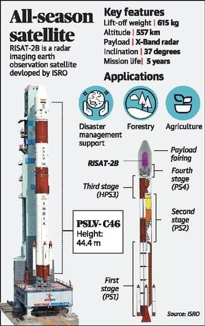
- RISAT-2B will mark the resumption of a vital ring of Indian all-seeing radar imaging satellites after seven years.
More in news
- Reconnaissance capability: At least a half-dozen could be foreseen in the near future, mainly to add to the reconnaissance capability from about 500 km in space.
- Constellation of satellites:(1) A constellation of such space-based radars means a comprehensive vigil over the country.(2) Numbers of satellites are in queue. RISAT-2B is to be followed by RISAT-2BR1, 2BR2, RISAT-1A, 1B, 2A and so on.(3) If ISRO orbited its first two radar satellites in 2009 and 2012, it plans to deploy four or five of them in 2019 alone.
- All-weather seeing feature: These satellites are equipped with an active sensor, the synthetic aperture radar (SAR), can sense or ‘observe’ Earth in a special way from space day and night, rain or cloud.
- Uses:(1) Useful for security forces, disaster relief agencies.(2) Radar imaging satellites pick up structures, new bunkers very well, and sometimes help to count them, too.(3) India also uses radar imaging for crop estimation because our main crop growing season of kharif is in May-September when it rains and gets cloudy.Complex task:(1) A radar imaging satellite is complex to assemble. Interpreting its images is equally complex.(2) ISRO took almost 10 years to realise RISAT-1.(3) It sends much heavier data than plain remote sensing satellites.
Source
The Hindu